
The Road to Montana - The Bozeman Trail
Leaving Rapid City, we set out on I-90 heading west towards to Bozeman. Along the way we passed through the tourist trap of Deadwood. A fun little place to stop for lunch, it's now a fun little town filled with restaurants and casinos. While I wouldn't spend more than an afternoon there, the town was full of people coming for a look at a historic western town known for its outlaws. After stopping in for lunch, and as stroll through the historic downtown, we set out again for Fort Phil Kearny. The amazing thing about this post that, except for the final post, all of these things can be found immediately off the interstate. That shouldn't be surprising though. The trails that pioneers and Native Americans used 150 years ago were largely paths carved by herds of buffalo over centuries. Those trails turned into roads, which in time have turned into highways and interstates in the modern world. Along the way you will pass Devil's Tower National Monument. You owe it to yourself to stop in. The trail is short, less than two miles, and can be done in less than an hour. The only reason we didn't include more pictures is because a downpour erupted about five minutes into our hike, but we prevailed. If you want an idea of the scope of this monster, play a little game of Where's Waldo with this picture.


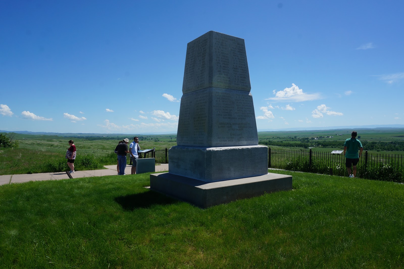
Fort Phil Kearny is one of the most important sites in the history of the West, and sadly is barely known outside of the people who live in the surrounding states. Overshadowed by its more famous counterpart, Little Bighorn, Fort Phil Kearny is the location of one of the worst massacres in American military history. For those of you who don't know, a man named John Bozeman set out in 1863 to create a path from the southern Wyoming territory to the gold fields that were booming in the Montana territory. That path, today known as the Bozeman Trail, followed a buffalo migration pattern, and went through Sioux lands that had been given to them during the Treaty of Fort Laramie in 1851. Originally the Sioux were okay with settlers passing through because they were not staying in Sioux lands, but as more and more settlers passed through on the Bozeman Trail they began attacking these caravans of Americans moving north. After demands from miners and pioneers, the U.S. Army began building forts along the trail to protect travelers. Fort Phil Kearny was one of those forts, and provided protection for a 30-40 mile stretch between it and the next fort. Eventually the Sioux and the U.S. Army clashed, which led to one of the great western wars known as the First Sioux War, or Red Cloud's War. On December 21st, 1866, soldiers in the fort were out gathering fire wood when several soldiers were attacked by Sioux. One of the officers in the fort was Col. William Fetterman. An impulsive man, he was ordered only to proceed to a specific hill with 80 soldiers, but not to proceed beyond that hill because he could not be viewed from the fort. Fetterman and his men left the fort, but did not follow orders, and went beyond the hill where they were supposed to stop. Waiting for them over the hill was a force of thousands of Sioux led by the famed warrior Crazy Horse. Over the next hour, all 81 American soldiers were killed in what became known as Fetterman's Massacre. To add insult to injury, the Sioux used an estimated 40,000 arrows to kill the 81 soldiers. This was the largest defeat in the western wars for the military until the aforementioned Little Bighorn came along a decade later. At modern day Fort Phil Kearney you can examine a recreated fort wall, and a ranger station with a well kept museum full of information about the Bozeman Trail and the Sioux Wars. From there, proceed about two miles up the road to the Fetterman Monument. A stone obelisk type structure, the monument is built on the site where they were killed. You can see from the location they had fallen outside of the view of the fort, and were on their own once they crossed that hill. For those with the pioneer spirit, there is a trail from the Fetterman Monument you can walk, it's the actual Bozeman Trail. It's amazing that wagon ruts still exist a century and a half later that show how well used this path would become in western expansion.


After leaving the site of the greatest defeat of the U.S. Army at the hands of the Native Americans up to that point, we headed up I-90 to find perhaps the most famous location in western history, and sadly, the site that would replace Fort Phil Kearny as the worst defeat in American history. Little Bighorn Battlefield National Monument is only about 80 miles up the interstate from Fort Phil Kearny. Completely surrounded by the Crow Indian Reservation, Little Big Horn is the location of the famed last stand made by Col. George Custer, and his 7th Calvary. Following Red Cloud's War, the Sioux signed a treaty with the government creating the Great Sioux Reservation in what is now South Dakota. The U.S. government promised no Americans would interfere on their lands, and lived up to their word until the Depression of 1873 hit. In 1875, gold miners who went into the Black Hills of South Dakota without Sioux permission, found gold in the hills. Needing money desperately to kick start the economy, President Grant did little to stop these miners from breaking the treaty the government had with the Sioux. Angered by this violation, Lakota Sioux Chief Sitting Bull decided to pull his people from the reservation, and return to their nomadic way of life in the Montana territory. Enter into this story Col. George Armstrong Custer, one of the nation's most famous heroes from the Civil War, who had fallen on hard times after becoming a thorn in Grant's side, and having been shipped out west to oversee the Sioux reservations. Wanting to make a name for himself by tracking down the most famous chief in the country, Custer and more than 600 soldiers tracked down the more than 1200 Sioux at a river the Crow called Little Bighorn. Custer divided his forces into three parts, and attempted to ride the ridge line so that he could trap the Sioux in the valley. Custer's plan was for the first part to attack, pull the warriors away from the women and children, and then while the warriors fought that group, the other two would capture the women and children, and force the warriors to surrender. The first group, led by Major Marcus Reno, was not able to hold the attack long enough, and retreated. This allowed the warriors to return to their camp before Custer and his men could capture the camp, and they were overrun by a force more than five times their size. In the end, they made their "last stand" by killing their horses and trying to make a defensive wall that could hold long enough for reinforcements to come, but those reinforcements never came. In the end, Custer, and all his 268 soldiers were slaughtered in what became the worst defeat in U.S. Army history during the Indian Wars. The battle site today looks almost identical to how it must have looked in 1876, minus the interstate running a mile away. Nothing more than rolling hills, and a small creek, you can imagine how remote this location was because it feels just as remote today. The ranger station has a wonderful museum that includes some of Custer's personal uniforms from both the Civil War and his time in the West. It also contains artifacts collected from famous Sioux warriors of the time like Crazy Horse, who was also at this battle, and their chief, Sitting Bull. There is a trail that will take you the three miles that separated the different attacks, but you can also drive it if you like. Right outside of the ranger station is Last Stand Hill, which is marked by a monument to all of the soldiers who died in the attack. Right beside the monument you will find the burial ground for those who died on Last Stand Hill, including Custer himself, well at least part of him. Apparently after he died they took half of his remains back to West Point to be buried, so he is one of the few people buried in multiple places. After you look around that hill, go see the markers that are spread throughout the park that are American soldiers that died, and the maroon markers are placed there by Native Americans to mark where their ancestors died in the same battle. Walk across the street and see monument the Native Americans opened in 2002. This unique monument includes the names of those who died there, and contains an unbelievable picture of the remaining warriors who showed up on 1946 to mark the 70th anniversary of the battle.


Leaving Little Bighorn, we set out for a historic site that has nothing to do with Native American wars. Instead, it is a historic location for one of the most amazing stories in American history, the two year epic journey of Merriweather Lewis and William Clark with their Corps of Discovery to map the newly acquired Louisiana Territory. In 1803, Napoleon Bonaparte was at war with what seems like all of the monarchies of Europe in the Napoleonic Wars. Needing money to fight his war, and not able to maintain the territory in the Americas he had taken from the Spanish after his conquest of the country, he decided to sell Louisiana to the United States. Thomas Jefferson agreed to pay $15 million for the territory that doubled the size of the United States in one day. With this territory now in American hands, this largely unknown territory needed to be mapped. Jefferson hoped a water path to the Pacific could be found that could help increase trade with Asian nations. To map this territory, and to inform the Native Americans in the West they now had a new "Great Father" he sent the Corps of Discovery on one of the great expeditions in human history. Setting out from St. Louis in the summer of 1804, Lewis and Clark led their men on a more than a year long journey up the Mississippi River, and then up the Missouri River. After making it to modern day Oregon, they spent the winter living among the Native Americans, and then set out to return home in 1806 to detail everything they had accomplished. On that return trip they decided to split up and explore two rivers, the Yellowstone River and the Marias River. At Pompey's Pillar National Monument, you get to experience this journey and imagine what life must have been like for those brave explorers more than two centuries ago. Pompey's Pillar, named after the baby that Sacagaewea had while helping with the journey who William Clark called "Pomp," is a massive stone outcropping that rises up within feet of the Yellowstone River. On this site on July 25th 1806, as William Clark and his men passed the site they noticed the natives had carved images along this important stone hill. William Clark carved his name and the date into the stone to mark their progress, and to connect with the natives whose land they were passing through. This is the only physical evidence, outside of the Smithsonian Institute, that demonstrates the path they took on this journey. Climb to the top of the hill and you will see all the way to the Rocky Mountains a hundred miles to the west, and will understand why control of this hill was critical to local tribes for centuries. Inside the information station you will see the best museum I've found about the Lewis and Clark voyage. As you wander around outside, look for the wild looking creatures called marmots that seem to be looking at you from every stone in the park. A massive relative of prairie dogs and chipmunks, these creatures are like nothing you've ever seen. Move slowly though because they spook easily, and will hide underneath their rocks at the drop of a hat.


One of the wildest parts about getting to Pompey's Pillar was the path to getting there. Getting off of I-90 before Billings, Google Maps sent us on what is humorously called Fly Creek Road. We took a step back in time a century and were immediately sent on a gravel road that was fifteen miles long through remote grazing land. Without cell phone service, homes, gas stations, or any living creature other than bored cows staring at the one car that passed through this land each day, we got as close as any modern traveler may be able to get to the western explorers, well at least for half an hour. While I'm being facetious, it would have taken an entire day to walk down this trail if we had broken down. I can't imagine what those Native Americans and pioneers felt like if their horse got injured or they got lost hundreds of years ago. These stops are all completely possible to visit in one day, and are worth the trip out west alone, but if you are coming out to the Big Sky country for another reason you need to make time to visit these historic sites and understand how far we've come as a nation, but also get a glimpse of how much of the nation still looks unchanged from the time of our ancestors.


Post a Comment